New in gINT V8i
gINT SoftwaregINT is the leader in software for Geotechnical and Geoenvironmental data management and reporting with over 7,700 licensees in 68 countries. Datgel is an authorised global reseller of gINT. As of 2026, gINT can only be sold to accounts/companies that hold existing licenses.
| ||
From point solutions to systems customized to your requirements, leverage Datgel's advanced knowledge and experience with gINT:
|
|
gINT Version V8i (8.3) - New Features
There are over 105 new features in gINT version V8i (8.3), here are some of our favourites:
- DGN CAD file export (All levels)
- AGS4 Format support (gINT Pro and gINT Pro Plus)
- ECW Air photo in Site Maps (All levels)
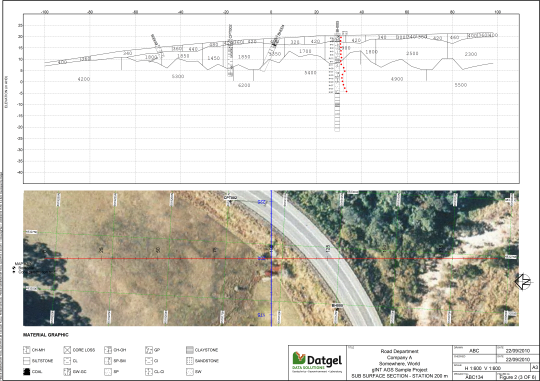
- Fence drapes to superimpose images/drawings on Fence reports (cross sections/profiles) (gINT Pro and gINT Pro Plus)
- Interpreted layered geometry
- Geophysics profiles such as Seismic Refraction velocity and Ground Penetrating Radar
- Existing features along an alignment (rivers, bridges, buildings, roads, etc.)
- ProjectWise Integration - basic (All levels)
- New Geo-Coordinate Tools (gINT Pro Plus)
- Same coordinate tool in MicroStation and Bentley mapping products
- For example, you can now enter Northing and Easting coordinates and generate the corresponding WGS84 latitude and longitude. Likewise, you can also enter the WGS84 latitude and longitude to get the Northing and Easting coordinates.
- Data entry, import/export with SQL Server (gINT Pro Plus)
- Downhole borehole survey for deviating boreholes (All levels)
- ArcGIS Toolbar included in gINT Professional and Professional Plus
Fence Drape and ECW air photo
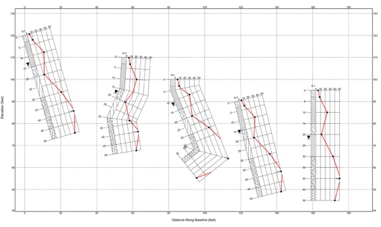
Deviated Borehole Support
Geo-Coordinate Tools

If you are an existing member, Log in here to access brochure